Anchorages
Hospital Cove, off the south channel, is well sheltered with depths of 7 to 10 feet. The narrow finger of deep water just east of Bassetts Island is a popular alternative. More convenient, though less protected, is the area between the south end of Bassetts Island and Scraggy Neck. This outer anchorage is useful as a short stop before or after transiting the Canal rather than as an overnight anchorage.
Small-craft Facilities
Parker’s Boatyard is on the east side of the small cove, about 300 yards south of the marina. Kingman Yacht Center is on the east shore of Red Brook Harbor about 500 yards southeastward of Handy Point. Both facilities have berths and moorings available for transients, electricity, gasoline, diesel fuel, water, ice, marine supplies, and storage facilities, and can make hull and engine repairs. Electronic repairs can be made at the marina. Depths of 8 feet are reported at the marina berths and at the boatyard berths.
Tides
Mean tidal range is 4 feet.
Harbormaster
508-759-0623
VHF 16
Emergency Services
Coast Guard
Cape Cod Canal
508-888-0335
VHF 16
Tow Service
Sea Tow
800-4SEATOW
VhF 16
TowBoatUS
800-391-4869
VHF 16
Pocasset Village, located at the intersection of Barlow’s Landing Road and Shore Road, has a bakery shop, gas station, pizza and seafood restaurants, small variety store, barber shop and church, which are within an easy walk of Barlow’s Boatyard in the Pocasset River but are a bit more of a hike from Kingman’s or Parker’s Boatyard in Red Brook Harbor.
Bassetts Island is nearly deserted, and the southern portion of the island is owned by the town (Bourne). The island’s beaches make a good destination for dinghy exploration. (Note that the northern part of the island is private.)
The mainland shores are similarly attractive and lightly developed. Within a mile of the harbor, the Bourne Conservation Trust controls nearly 100 acres of woods and fields, connected by a network of trails. You can pick up a trail guide from the office at Parker’s Boatyard.
Navigation:
NOAA charts 13236, 13229, and 13230
CharKit Region 2 pages 33 and 35
ChartKit Region 3, pages 75 and 83A
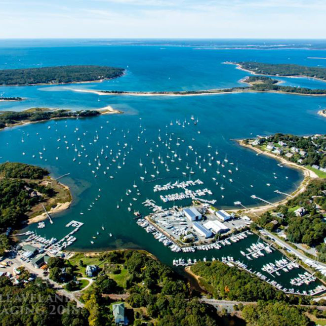
Pocasset and Red Brook Harbors share a common entrance between Scraggy Neck to the south and Wings Neck to the north. Bassetts Island separates Pocasset Harbor from Red Brook Harbor. Broken ground with depths of 17 to 19 feet in places extends across the entrance.
Eustis Rock, about 0.2 mile north of Scraggy Neck (N41°40.45′; W070°38.80′), is covered 5 feet and marked by a buoy. This is the turning point to both harbors. The area eastward of Eustis Rock to Bassetts Island is shoal.
A narrow buoyed channel, with a depth of about 8 feet leads north of Bassetts Island to Pocasset Harbor. Barlows Landing, at the northeast end of the harbor, has a depth of 11‚ÅÑ2 feet. A small-craft launching ramp is just south of the landing.
Hospital Cove, about 0.2 mile southward of the southern end of Bassetts Island, is entered through a natural buoyed channel that leads southeastward from a point about 0.4 mile east-southeastward of Eustis Rock to a small anchorage in the cove. A depth of about 6 feet can be carried in the channel, and there are depths of 8 to 14 feet in the anchorage. A shoal at the south tip of Bassetts Island is reported to be shifting westward in the vicinity of Buoy 3; so stay mid-channel and exercise caution. A boulder reef extends northeastward from Scraggy Neck in the approach to the cove. Several private piers with depths of 5 to 8 feet alongside are in the cove.
Red Brook Harbor, east of Bassetts Island, is approached from the northward through the channel that leads through Pocasset Harbor, and from the southward through the channel that leads through Hospital Cove. Hen Cove is immediately northward of Red Brook Harbor. The channels are buoyed. Depths of 8 feet and 6 feet can be carried through the north and south channels, respectively. Because of numerous submerged rocks in and near the edges of the channel, local knowledge is advised.